America's Highway Numbering System Is Hiding A Giant Math Puzzle
Ever wondered how the highway and interstate numbers came to be? What do they even mean if they mean anything at all? Behind those numbered shields displayed on the signs is a mathematical logic grid that most of us might be completely unaware of. The U.S. highway numbering system isn't random at all. It's intentionally structured so that you can read the road like a map. Yet, we rarely appreciate that we're cruising through an engineered puzzle every time we merge onto an interstate.
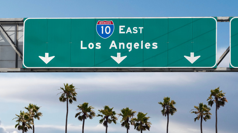
Let's make it simple. Even-numbered routes run east-to-west, and the odd numbered ones run north-to-south. Lower numbers start in the south and west, while the bigger numbers are in the north and east. That means Interstate 5 (I-5) hugs the West Coast while I-95 runs the East Coast. I-10 cuts across the deep south, while I-90 is in Massachusetts and stretches all the way to Washington. Once you know that, you can eyeball any two-digit interstate and know where it's going. The numbered systems — both for the older U.S. Highways and the newer Interstate grid — turned what was once a wild web of named roads into something you can decode. There's more to it, so buckle up, because we're going deeper into this road network matrix.
The grid that tells you where you are
Think of the highway map as a giant coordinate plane. We've already established the basics — on the Interstate system, odd numbers run up and down (i.e., north-to-south) and even numbers go left to right (i.e., east-to-west). On top of that, the lowest Interstate numbers start in the west for the north-south routes and in the south for the routes going east to west. Now, this is true for single- and double-digit interstates.
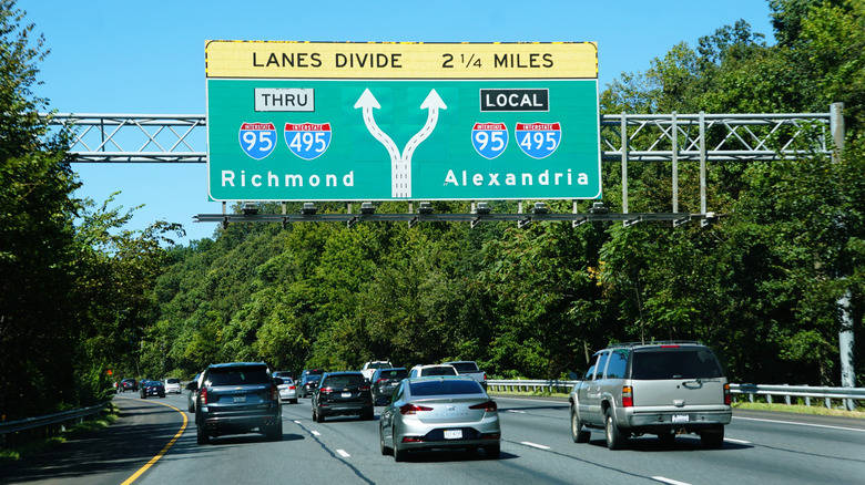
Three-digit interstates throw a logical curveball into the mix. These interstates act as spurs or belts off the main two-digit trunks. When the first digit is even, it's typically a loop or ring road around a city. When you spot an odd-numbered first digit, it's a spur ending at the primary route. For instance, I-495 loops around Washington, D.C., and I-395 is a spur off I-95. The system is far from perfect, though. States sometimes get creative, so exceptions still exist — some old roads are still in use, and geography forces adjustments as well. For the most part, however, you can look at an interstate number and figure out its place in the network. It's a complex grid, simplified with rules and logic.
But there's a plot twist. Some major routes actually split in two, each branch keeping the same number but tagged with a letter denoting the direction — like I-35E through Dallas and I-35W through Fort Worth, which later reunite at Denton. To avoid confusion elsewhere, three-digit prefixes are used for spurs and beltways, even first digits for loops (I-280, I-480, I-680), and odd for spurs (I-180, I-380, I-580). It's orderly and logical once you understand the system, but just chaotic enough to remind you that humans designed it.
Exploring a weird mathematical possibility

If you really want to geek out, imagine pushing that logic further. Picture a world where every local route used prime numbers instead of arbitrary digits, so say Route 2, Route 3, Route 5, Route 7, and Route 11. Now, if two of those prime routes connected, their linking highway could be numbered by multiplying them together. Route 3 and Route 11 would make up Route 33, the product of their primes. A road that loops back to itself could be the square of its number, so Route 3 multiplied by 3 would equal Route 9, which connects back to Route 3.
Let's take it even further: a road joining three prime routes — say 2, 3, and 11 — could be Route 66 (i.e., 2 multiplied by 3 multiplied by 11). It sounds absurdly nerdy, but it would work every time because each product of primes is unique. In theory, every highway's number would tell you exactly which other roads it connects to. Of course, in the real world — where America's lost highways stand as beautiful monuments to its garbage infrastructure — numbering is seldom that elegant.
Where did the U.S. numbered highway system come from?

Before America's roads became a clean grid of numbered routes, they were a chaotic patchwork of named trails. By the mid-1920s, more than 250 named highways crisscrossed the country, proudly painted onto barns, telephone poles, and fences by trail associations. The problem was that paint – even glow-in-the-dark paint — could barely withstand the weather, so a more robust system was required.
Some of the popular older highways included the Dixie Overland Highway running from Savannah to San Diego, the Lincoln Highway connecting New York to San Francisco, and the Yellowstone Trail spanning Boston to Seattle. The problem with this system was that many of these routes overlapped, wandered through towns that paid dues to their associations, and often ignored efficiency altogether. In some cases, five or six different highways shared the same stretch of road, leaving travelers guessing.
The confusion eventually reached its breaking point. Wisconsin stepped up first, replacing its tangled collection of named routes with a numbered trunk highway system in 1918. Other states quickly followed suit, realizing that numbering was clearer and scalable. By 1926, the American Association of State Highway and Transportation Officials (AASHTO) created the unified U.S. Numbered Highway System, replacing hundreds of vanity names with a simple, expandable grid that we know today. That introduced the method of using odd numbers for north-south corridors, while using even numbers for the east-west ones. Major cross-country highways got zeros and ones, like the U.S. 1, U.S. 20, U.S. 40, and the shorter connectors and branches adopted three-digit extensions. The resulting mathematical roadmap system turned chaotic named trails into a predictable format. The idea was to give drivers intuitive cues long before GPS became commonplace, and it still works.
Exceptions, tweaks, and weirdness

On paper, America's highway numbering system is pure genius. It's a neat little grid that makes sense in a way some of the worst automotive laws and regulations do not. Once you try using that logic on the messy sprawl of real-world geography with mountains, rivers, cities and political boundaries, things get a bit complicated. Take I-50, for instance — or rather, don't, because it doesn't exist. The number would clash with U.S. 50 in the same states, and tempting that kind of chaos would be a nightmare.
Then there are the oddballs that break the rules simply because of geography. Maryland's I-270 is one such rebel since it's a spur that only connects to I-70 at one point yet somehow gets an even first digit, the mark of a loop. It even has its own spur, I-370, in Gaithersburg, while another spur off the same road in Bethesda gets left out of the numbering party entirely.
But the crown for highway numbering weirdness goes to California's I-238, a road that logically shouldn't even exist. There's no I-38, so there can't be an I-238. Yet, there it is, and it's connecting I-580 and I-880 — a bureaucratic glitch in existence. Technically, the I-238 could've been an I-x80 number, but California ran out of I-x80 numbers, so it slapped its old state route number (California Route 238) onto it instead. Innovation or mathematical chaos? We'll let you decide.